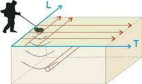
To finalize the 3D geophysical investigations, we made use of ground penetrating radar (GPR) georadar, which allows us to investigate both the subsurface and structures and noninvasively reveal the possible presence and location of buried objects, metal objects, and anomalies in masonry structures using the phenomenon of electromagnetic wave reflection.
The method of analysis is based on the principle of propagation of electromagnetic pulses in materials and their reflection at those discontinuity surfaces attributable to changes in permectivity of the materials investigated.
Data acquisition is accomplished by sliding a pair of antennas (one transmitter and one receiver) maintained at a constant distance over the surface to be investigated.
In the central unit of the apparatus, signals are generated at regular intervals that serve to stress the electronic circuits of the transmitting antenna.
Electromagnetic pulses are radiated from this, which, propagating through materials, are reflected at the interfaces between materials with different dielectric characteristics.
Reflected events are picked up by the receiving element and sent into the central unit for further processing.
The equipment allows real-time display of the recorded radargram on a color display for preliminary quality control, and simultaneously stores the data on associated notebook for later processing with dedicated software.
Subsequent digital processing of the data makes it possible to improve the interpretability of the acquired data through filtering operations, normalization, amplification, etc. in order to make the presence of any anomalies more obvious.
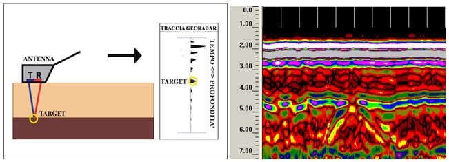
On the horizontal axis of the radargrams are displayed the metric progressions of the recorded line, while on the vertical axis are the double path times (outward and return) of the reflected paths.
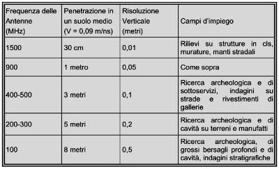
The horizontal resolution of the signals is inversely proportional to the speed at which the antenna is moved; the vertical resolution is directly proportional to the center frequency of the emitted pulses.
The intensity of reflected events is stronger the greater the contrast between dielectric variations.
The depth of investigation cannot be established a priori of the survey but depends on the absorption of electro magnetic energy by the materials in which it propagates. The depth depends on the nature of the media traversed, the physical state of the constituent elements, and environmental and/or local factors: temperature, humidity, presence of cavities, etc.
Moreover, the prospecting target and penetration depth are constrained by the wavelength of the pulses: in fact, if a buried structure is very small in size, it is detected only with signals of very short duration whose high attenuation at the energy level, however, limits its penetration.
In summary, antennas with high frequencies allow good resolution down to modest depths; antennas with low frequencies offer relatively less detail, but allow a greater extent of measurement from the surface topography.
The presence of water or moisture in the materials under examined, results in an increase in the relative dielectric constant and thus a decrease in the speed of electromagnetic pulses. Knowledge of the relative dielectric constant is useful in determining the type of material being investigated and its degree of moisture.
The definition of such anomalies is provided at the data interpretation stage, based on the type (e.g., shape of the object that caused the reflection) and planimetric continuity of identical or, at any rate, similar events.
It is important to remember that the measurement procedures used for the geophysical survey of Villa Peticia are based on indirect exploration techniques that have a number of inherent limitations regarding the propagation of the electromagnetic wave. This wave depends on the dielectric constant of the materials: in clay materials with high dielectric constant or in the presence of water, the attenuation of the signal is high with the risk of not detecting any discontinuities/objects present.
The geophysical survey cannot all way never be considered a complete substitute for direct exploration.
The Georadar system used
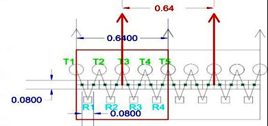
A 3D georadar system, equipped with 9 shielded antennas at 400MHz, was used in the present investigation for exploration depths within 3m.
The system encloses within it 5 transmitting and 4 receiving antennas of the same frequency, and the combination of transmitting and receiving causes 8 parallel profiles to be obtained simultaneously at each pass.
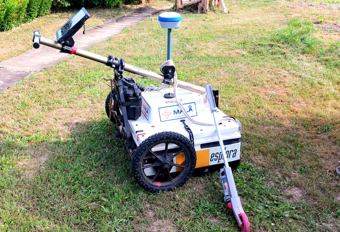
The 8 profiles are spaced by a fixed offset of 8cm. Together they occupy a 64cm band. The positioning system involves the use of an odometer and where possible interfacing with GPS or total station.
This very complex system was developed to identify archaeological finds quickly and with very high resolution.
The system facilitates the interpretation of the signal by highlighting continuous structures, and avoids making errors in interpolations of 2-dimensional profiles.
Acquisition in the 3 directions of space makes acquisition independent of the often unknown orientation of the target.
The 3D system is connected to a laptop from which acquisition parameters can be managed and the acquisition of each swipe can be viewed in real time.
The technological limit ical limitation of the 2D and 3D georadar methodology, in each case is the depth of the water table, since it completely absorbs the electromagnetic signal.