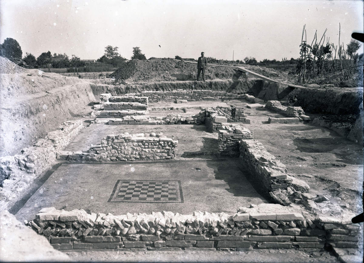
The structures related to the villa identified during the excavation phase are represented by at least three rooms aligned on a southeast/northwest axis open to a probable uncovered area located to the west of them.
The structure shows at least three phases of renovation, in the last of which, the largest room located south and st of the structure and recognized as a triclinium, was subdivided into smaller rooms.
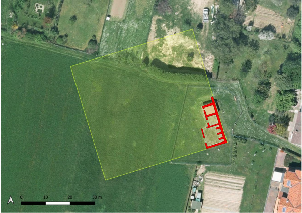
The characteristics of the identified wall structures, the lack of openings along the east and south walls of the rooms and of traces of walls on the external face, seem to indicate that the portion of the villa discovered is the one related to the southeastern corner, and that it therefore developed towards the north and west, for an estimated extension d i 2500 square meters.
The archaeological data recovered as a result of the excavations would thus seem to validate the hypothesis that in the area south of the structures there may be no masonry structures belonging to the main body of the villa, a theory that does not, however, imply the lack of buildings or outbuildings pertaining to the villa but not physically connected to it.
Georadar surveys have identified some interesting anomalies at an average depth estimated between 60 to 1 meter in depth, the same elevation at which the ridges of the identified structures stand.
The data were interpreted in order to identify any anomalies attributable to buried structures of archaeological interest.
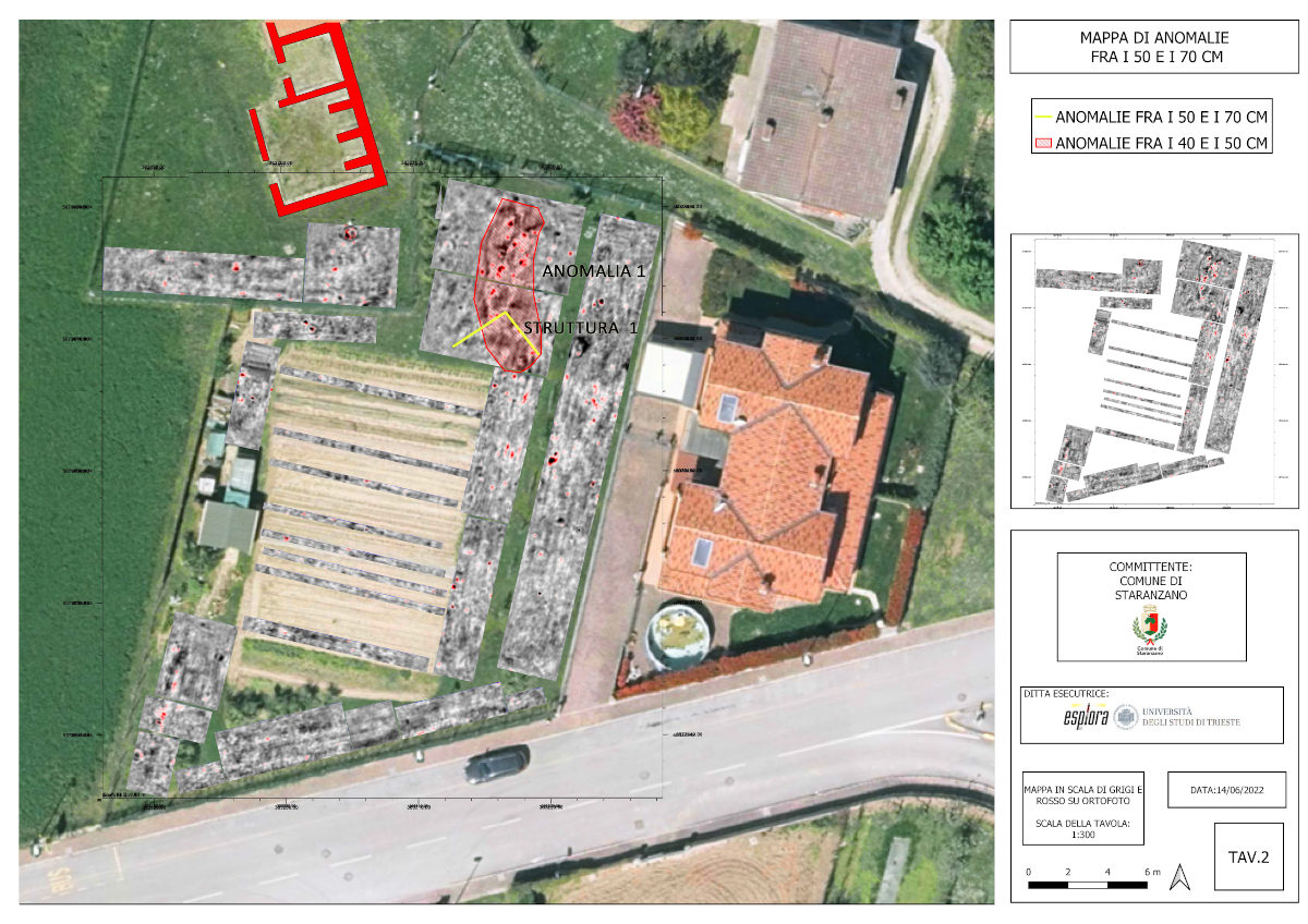
Data processing identified three distinct groups of anomalies located at different depths from 40-50 cm above ground level, all in the eastern range of the field.
The anomalies were classified according to their type, stratigraphic position, and geometry.
It should be pointed out that an error in depth of +/-0.15-0.20m should be considered for depth and -/+0.10-0.15m for width of anomalies, due to instrument resolution, interference and possible systematic errors.
Tables
Table 1 - Depth between 40 and 50 cm: In the northeastern part of the field, immediately southeast of the villa structures, an irregularly shaped anomaly appears at a depth of about 50 cm, running from north to south covering an area of about 60 square meters (see below image 'longitudinal and cross sections of Anomaly 1').
From its shape and development in depth, the anomaly is funnel-shaped and could be associated with a pit filled with inconsistent material, probably a post-depositional intervention that also affected the underlying archaeological levels.
It is conceivable that it can be explained as an intervention of destruction or spoliation of underlying structures.
The hypothesis could be supported by the presence in the same area, from 50 cm depth, of traces of linear anomalies that, descending in the stratigraphy, assume a more linear geometry, revealing themselves as probable wall structures related to a building located southeast of the villa structure.
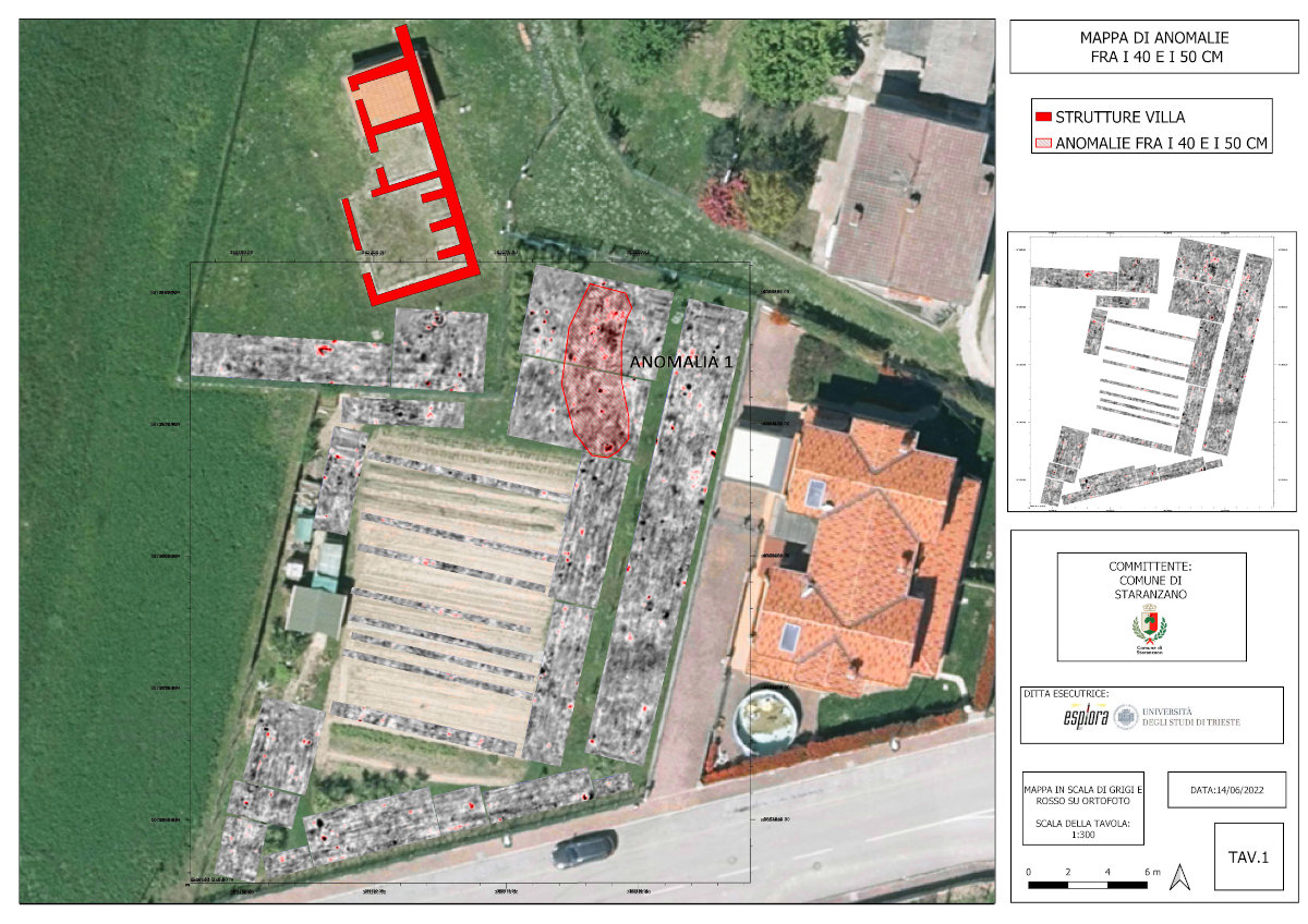
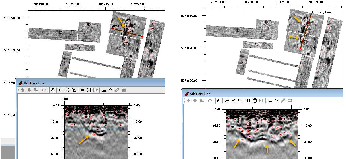
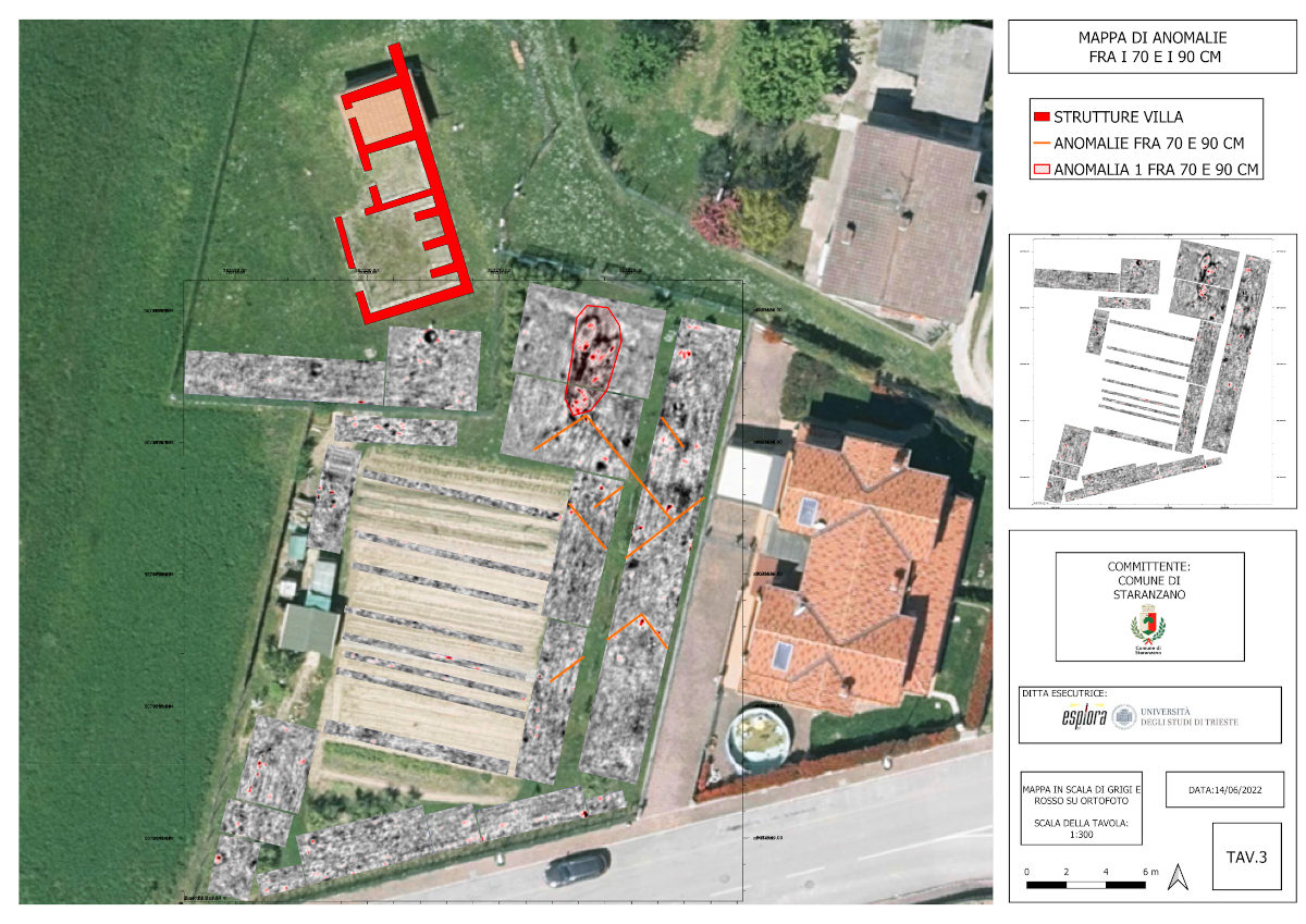
Table 2 and Table 3 - Depth between 70 and 90 cm: At this depth the wall structures identified in the higher levels take on a more precise physiognomy, while the trench reaches maximum visibility before disappearing around the depth of 1.20 m. From 70 cm other linear and isoriented anomalies are added to those already highlighted in the higher levels, probably as a matter of preservation of the elevations.
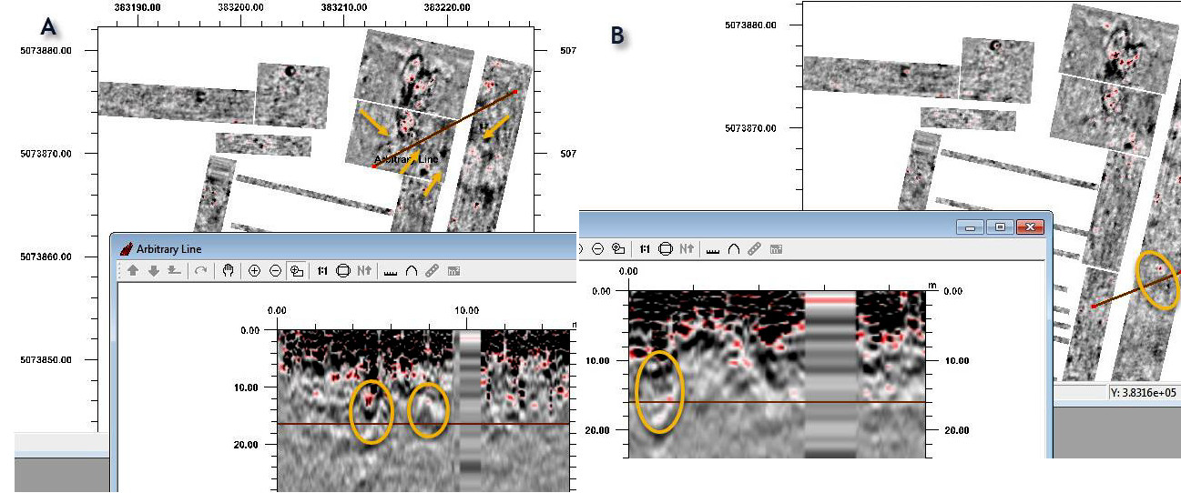
In more detail, the first building (see below image 'A evidence from Structure 1) seems to be characterized by two longer walls with a northwest/southeast orientation (the east one is visible in its entirety), at the ends of which are two smaller arms perpendicular to these: the space created by these walls seems to be further divided into two rooms by an intermediate wall septum. At the level of the southeastern head of the east wall of the building we seem to see the trace of an additional structure running eastward and extending the southern limit of the building on this side. East of the longer wall is the trace of a further wall alignment, parallel to it and probably pertaining to the eastern limit of a third room. Of the second building (see image 'B evidence of Structure 2' below), located to the south of this one, a long wall is identifiable that runs parallel to the south side of the first, and a second structure that creates a 90-degree angle to the southeast, starting from the east head of this one.
The sign is less legible than that for the first building, probably because of the level of preservation.
At this depth it is therefore possible to reconstruct the presence of at least two buildings, oriented toward each otherand not physically connected to the main body of the villa.
The orientation of the identified buildings also does not reflect that drawn by the walls exposed in the excavation, although this element does not collide with a direct relationship between the structures.
Depths between 90 and 120 cm: the signals related to the first structure are readable up to a depth of 1.10 m, after which it becomes more difficult to read its geometry. As for the anomaly related to the ditch, this is clearly identified at least up to a depth of 1.20 m, and then gradually disappears.